
Eire Vacuum Services Blog
Safe Excavation Near Underground Services: A Sydney Site Checklist
Samantha manages enquiries, bookings, and the day-to-day business side at Eire Vacuum Services.
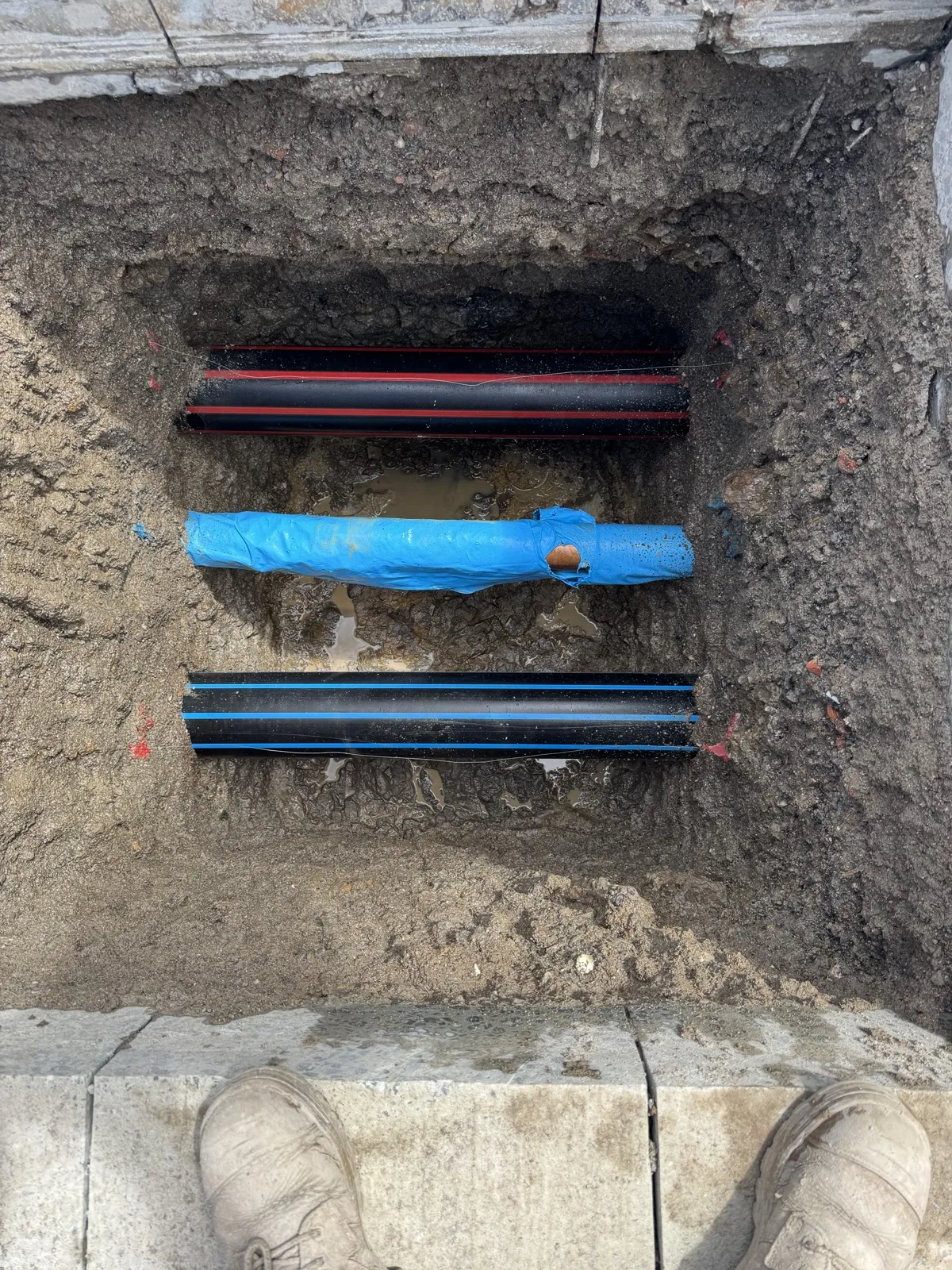
Safe excavation near underground services follows one order: get current plans before anyone starts, check what the plans actually claim, locate and mark on site, physically expose the service at the points that matter, then protect what you have exposed before the machine goes in. The plans are the starting point, not the answer. Every step after them exists because a plan tells you a service is somewhere nearby, not where it is.
Key takeaway
A service strike is what happens in the gap between two different things: knowing a service is around here somewhere, and knowing where it is. Plans, records and locating close part of that gap. Only physically exposing the service closes it at the point you are about to dig, and even then it closes it at that point and nowhere else along the run.
What NSW actually asks of you before the machine arrives
The duty sits with whoever is running the work, not with the operator who turns up. SafeWork NSW puts it in plain terms: "When excavation work is carried out, get information about the underground essential services that are at the site and at any adjacent areas, before work commences," and then "Give that information to anyone you engage to carry out the excavation work."
Two details get missed on real sites.
- "and at any adjacent areas." The scope is not your work footprint. A service running through the neighbouring lot or under the verge is in scope if your excavation is near it.
- "before work commences." Not before the excavation reaches depth, and not on the morning of. Before the work starts.
SafeWork NSW’s own excavation hazard page is blunter about where that information comes from: "Don’t dig blind! Before you start any excavation you must first check with Before You Dig Australia so that you know the location of essential utilities and services." The same page repeats the duty as an obligation to "obtain current essential services information where work is being carried out, and any adjacent area, before directing or allowing the work to commence."
Separately, the excavation itself may be high risk construction work. On SafeWork NSW’s wording, that includes work "carried out in, or near: a shaft, trench with an excavated depth greater than 1.5 m, or a tunnel," and "You must prepare a Safe Work Method Statement (SWMS) for high risk construction work before that work commences." A SWMS is a separate obligation from the services information. Having plans in the ute does not satisfy it.
What a Before You Dig enquiry gives you, and what it does not
A Before You Dig Australia enquiry is free and it is the correct first step. It is also the step most often over-read.
Before You Dig Australia says it plainly in its own best-practice guidance: "Plans provided by the asset owner only indicate the presence of infrastructure assets within the vicinity of the project site; they do not pinpoint the exact location."
The same guidance adds a second limitation that matters more than it sounds: "not all of Australia’s infrastructure asset owners are BYDA Members." A complete-looking response is not proof that every asset under your site has been disclosed. Private assets, older site services and non-member owners can all sit outside it.
There is also a currency rule that catches people out on longer jobs. Ausgrid states it directly: "NSW legislation requires people who are planning excavation work to obtain copies of underground electricity cable plans from Before You Dig Australia. The plans must be no more than 30 days old when excavation commences."
That is a hard date, not a guideline. If the enquiry was lodged during tender and the dig starts eight weeks later, the plans are out of date on the day that matters.
How reliable is your information? AS 5488 in plain terms
This is where the question people ask most often, "what is the Australian standard for underground services," gets a better answer than the one search results usually give.
There is no single Australian standard that covers underground services. Three different things do three different jobs: the WHS Regulation sets the duty, each asset owner sets the requirements for working near its own assets, and AS 5488 classifies how good your information is. AS 5488 was first published as AS 5488-2013 and was revised and redesignated in part as AS 5488.1:2019, which is the current edition. The wording and figures quoted below are from the publicly published excerpt of the 2013 edition, because that is the version whose text can be read without purchase. Anyone specifying or certifying to the standard should work from the purchased current text, not from this article.
What AS 5488 does is give you a way to say, without arguing about it, how much you actually know. In the words of the AS 5488-2013 excerpt, "A quality level describes the amount and accuracy of information that is collected or held on a subsurface utility." There are four of them, D, C, B and A, and A is the highest.
| Quality level | What it is | Stated tolerance (AS 5488-2013 excerpt) |
|---|---|---|
| QL-D | Compiled from existing records, a cursory site inspection, or anecdotal evidence | Tolerance does not apply to an indicative location at this level |
| QL-C | Existing records plus a site survey of visible evidence such as pits, valves and hydrants | Surface features to plus or minus 300 mm horizontally |
| QL-B | Relative subsurface feature location in three dimensions | Plus or minus 300 mm horizontal, plus or minus 500 mm vertical |
| QL-A | Positive identification of the utility at a point, in absolute three-dimensional position | Plus or minus 50 mm horizontal and vertical |
Quality levels as published in the AS 5488-2013 excerpt. AS 5488.1:2019 is the current edition.
Two clauses in that excerpt are worth knowing by heart.
The first is the default. "By default, if the metadata does not indicate a quality level, then the utility information shall be assumed to be at quality level D." If nobody has told you the quality level of what you are holding, the standard says treat it as the lowest one.
The second is what QL-A actually means. The AS 5488-2013 excerpt describes it as "the positive identification of the attribute and location of a subsurface utility at a point to an absolute spatial position in three dimensions. It is the only quality level that defines a subsurface utility as ‘validated’." And then the sentence that stops people over-claiming: "Where the whole line segment cannot be verified by line of sight, quality level A shall not be attributed to the line segment between validated points."
Read that last one again on site. One pothole validates one point. It does not validate the run between two potholes. A service can deviate, branch, or change depth between the holes you dug, and the standard explicitly refuses to call that stretch validated.
This is also what the locate step in the sequence is for. A locate is a survey carried out on site by a locator, using electromagnetic detection and, where conditions suit, ground penetrating radar, to trace and mark where a service appears to run. It is booked separately from the plans and separately from the excavation. What it produces is an interpreted position rather than a confirmed one, which in AS 5488 terms is the step that moves you off records-only ground toward QL-B. It narrows the search area so that potholing happens where it matters rather than everywhere.
For which site activity produces which of those levels, and where detection work stops and physical exposure starts, our guide to service locating versus service proving covers that mapping in detail. The point here is narrower: know which level your information is at before you decide the dig is safe.
Get a straight read on the exposure you need
Tell us what has to be confirmed before you dig
Send the plans, the marked-up locations and a photo of the access, and we can tell you what actually needs exposing before your excavation starts. Call 02 5023 3473, or send it through the contact page.
What is the 5 4 3 2 1 rule for excavation? It is not an Australian rule
This question comes up constantly, and almost every answer you will find is about a different country.
The 5-4-3-2-1 rule is a memory aid for United States trenching requirements under OSHA, measured in feet. The five comes from 29 CFR 1926.652(a)(1), which requires cave-in protection unless "Excavations are less than 5 feet (1.52m) in depth and examination of the ground by a competent person provides no indication of a potential cave-in." The 4 is egress. A trench "4 feet (1.22 m) or more in depth" needs a way out within "25 feet (7.62 m) of lateral travel", at 29 CFR 1926.651(c)(2). The 2 is spoil, kept "at least 2 feet (.61 m) from the edge of excavations", at 29 CFR 1926.651(j)(2). The 1 is the competent person, through the "Daily inspections" duty at the same regulation’s paragraph (k)(1). The 3 is in neither of those regulations. It is the ladder rule at 29 CFR 1926.1053(b)(1), where the side rails "shall extend at least 3 feet (.9 m) above the upper landing surface". One mnemonic, three separate regulations, and not one of them Australian.
For a Sydney job, that matters twice over.
- It is not the law here. Australian excavation duties come from the WHS Regulation and the SafeWork NSW codes, and the depth trigger people usually want is the 1.5 m trench threshold for high risk construction work quoted above, not 5 feet.
- It is not about buried services at all. The 5-4-3-2-1 rule is about the trench collapsing on a person. That is a real and serious hazard, but it is a different hazard from striking a live cable or a gas main, and following it tells you nothing about what is under your dig.
If someone on site cites the 5-4-3-2-1 rule as the reason a service dig is safe, that is a signal to slow down, not a reassurance.
How close can I work to underground power cables? The number belongs to the asset owner
This section is about buried cables. Approach distances for overhead lines are a separate SafeWork NSW regime with its own figures, and nothing here applies to them. For underground cables specifically, there is no single national number, and any article that gives you one without naming the asset owner is guessing on your behalf. The same is true across asset types: an electricity network such as Ausgrid or Endeavour Energy, a gas network such as Jemena, and a water and wastewater authority such as Sydney Water each set their own requirements for work near their own assets, and a single dig can sit over more than one of them.
The distance, and the method you are permitted to use inside that distance, are set by the asset owner in its own network standard and in the plan pack that comes back with your enquiry. In the Ausgrid network, that document is NS156. Ausgrid’s own guidance tells excavators to "Refer to NS156: Excavating Near Ausgrid Underground Cables or Conduit for comprehensive information."
So the practical answer is a process, not a figure:
- Identify the asset owner for every service in and adjacent to your dig.
- Read the requirements that came back with the plans for that owner.
- Where the plan pack or the network standard specifies a method inside a set distance, use that method. It is a condition of working there, not a recommendation.
- If two owners’ requirements overlap on the same dig, the stricter one governs that ground.
Treat any general metre figure you find online as no substitute for the requirement that came back with your plans. The number that governs your dig is in a document with your asset owner’s name on it.
The safest method for exposing a service
Before You Dig Australia’s own five-step framing answers this: Plan, Prepare, Pothole, Protect, Proceed. In its words, you "Pothole, if permitted, using the asset owner’s stated method as specified on the plans and information pack," then "Protect the infrastructure by using various methods; such as communicating to all working on site, erecting barriers," and only then "proceed with your excavation work after you have planned, prepared, potholed (unless prohibited)."
Some of that sequence carries more weight than it first appears.
- "If permitted" and "unless prohibited" are real. Some assets must not be potholed by the excavator at all, and the plan pack will say so. That is an instruction, not a formality.
- "Using the asset owner’s stated method." The method is specified to you. It is not yours to choose on the day.
- Protection is a step, not an afterthought. An exposed service left unmarked over a shift change is arguably more dangerous than one nobody has found yet, because the next crew has no reason to expect it.
Where a non-destructive method is the stated or permitted one, that is what vacuum excavation is for. It loosens and lifts soil away from the service rather than cutting through it with a bucket or a blade, which is the reason it appears as a permitted method on plan packs for work close to live assets. The assets it is used around are the ones a Sydney dig is most likely to meet: water, gas, electricity, sewer, stormwater and telecommunications.
What it does not do is remove any of the earlier steps. Vacuum excavation is the tool for the pothole. It is not a substitute for the plans, the currency check, the locate, or the asset owner’s method statement. If a supplier tells you their method makes the plans unnecessary, that is a reason to use someone else.
The Sydney site checklist
This is the order. Skipping a step does not save time; it just moves the risk later into the job, where it costs more.
- Lodge the enquiry at byda.com.au for the work area and the adjacent areas. BYDA asks you to lodge "at least one business day before your project begins".
- Check the date. For Ausgrid cables the plans must be no more than 30 days old when excavation commences. Re-lodge if the job has slipped.
- Read the plan pack, not just the drawings. The asset owner’s requirements, the permitted potholing method, and any prohibitions come with the plans.
- Walk the site for surface clues. Pit lids, marker posts, meters, valve covers, patched trenches and pavement scars. These are what turn a records-only picture into something checkable.
- Assume QL-D unless you have been told otherwise, and commission locating where the risk warrants better than that.
- Pothole at the points that matter, using the asset owner’s stated method, where potholing is permitted.
- Record what you exposed, including depth and offset, and remember one pothole validates one point, not the run between two of them.
- Protect and communicate. Barriers, marking, and a handover that the next shift actually receives.
- Then proceed, and stop and re-check if what you find does not match what you were told.
What we do on this, in practice
Eire Vacuum Services runs two truck sizes, 8,000L and 10,000L. For service exposure the choice rarely comes down to capacity, because a pothole produces far less spoil than a clean-out. It comes down to where the truck can legally and physically stand. That is why the smaller unit usually suits kerbside, laneway and tight civil access. The larger one earns its place when several exposures are planned in a run, or the same visit also has to lift water or slurry.
Before any job is booked we confirm the same list every time: truck size, hourly rate, estimated time, hose run, safety controls, disposal costs, disposal depot distance and waste type. On an exposure job the hose run is the line item that moves the estimate most. A service forty metres from the nearest legal truck position is a slower job than the identical exposure at the kerb, and one photograph of the access answers that faster than any amount of description.
We do not issue locating reports and we do not set the asset owner’s requirements. What we do is the physical exposure, to the method the plan pack specifies, so that the people who do own those decisions are working from a service they can see.
Where we work
Service exposure work takes us across Greater Sydney, and what changes from one part of it to another is rarely the dig itself. It is the access. Sydney CBD and inner-suburban jobs are usually decided by where a truck can legally stand and for how long. The Hills District, Western Sydney and the Sutherland Shire more often turn on hose length across a site. The Northern Beaches and Eastern Suburbs bring narrow streets and driveway grades into it. We also work Newcastle, Wollongong, the Central Coast and the ACT, where travel time is worth confirming before the day is booked.
Related services
If you need buried assets exposed before mechanical excavation, drilling or repair work continues, that is our non-destructive digging service. Where the job is a set of discrete exposures at known points, see potholing services. For a walk-through of the exposure itself, utility potholing explained covers what happens on site.
Frequently asked questions
How close can I work to power lines?
This answer is about buried cables; overhead lines are a separate SafeWork NSW regime and are not covered here. For underground cables, the distance and the permitted method are set by the asset owner, not by a single national figure. In the Ausgrid network the governing document is NS156, and the requirements for your specific job come back with your Before You Dig Australia plans. Identify the asset owner first, then work to that owner’s stated requirements.
What is the 5 4 3 2 1 rule for excavation?
It is a memory aid for United States trenching rules under OSHA, measured in feet, and it is about trench collapse and trench access rather than buried services. It is not an Australian rule. In NSW, excavation duties come from the WHS Regulation and the SafeWork NSW codes, where the commonly cited trigger is a trench deeper than 1.5 m being high risk construction work.
What is the Australian standard for underground services?
There is no single one. AS 5488, first published as AS 5488-2013 and revised and redesignated in part as AS 5488.1:2019, classifies how reliable your subsurface utility information is, from QL-D up to QL-A. The duty to obtain that information sits in the WHS Regulation, and the requirements for working near a particular asset are set by that asset’s owner.
What is the safest method for exposing underground facilities during excavation?
Potholing using the asset owner’s stated method, where potholing is permitted. Before You Dig Australia’s own guidance is to pothole using the asset owner’s stated method as specified on the plans and information pack, then protect what you have exposed before proceeding. Where a non-destructive method is specified or permitted, vacuum excavation is commonly used for that exposure.
Planning a dig near services?
Send the plans, the marked-up locations, the access photos and the section you still need confirmed. We can tell you what needs exposing, how long it is likely to take, and whether the truck can reach it, before you commit to anything. Call 02 5023 3473 or send the job details through our contact page.
Ready to scope the exposure?
Request a quote on your service exposure
Site photos, truck access and hose-run details are all we need to price it. If the job is already on the ground, call instead.
Every regulatory, standards and safety statement above was checked against a named public source on 31 August 2026, and anything that could not be checked against a primary source was left out rather than softened. That is why no approach distance to a live asset appears anywhere in this article. This is general information, not a site-specific assessment and not a substitute for your asset owner’s requirements, your Before You Dig Australia response, or your own safe work method statement. Requirements differ by asset owner, by asset type and by site.
References
SafeWork NSW, Doing excavation work. SafeWork NSW, Excavations and earthmoving plant in construction. Before You Dig Australia, Best Practice Guidelines. Ausgrid, Working near underground cables. Standards Australia, AS 5488.1:2019 Classification of subsurface utility information, with quality level wording quoted from the published AS 5488-2013 excerpt hosted by Radiodetection. US OSHA, 29 CFR 1926.652 Requirements for protective systems, 29 CFR 1926.651 Specific excavation requirements, and 29 CFR 1926.1053 Ladders.